
In the map segment below (from the CAD map for Queensland Two Mile Series - 1955) the station locations for Harrisville to Radford are detailed.
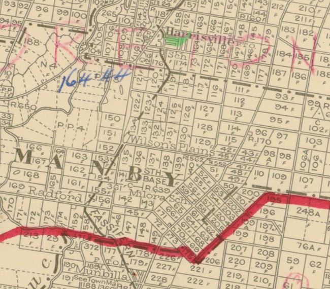
Segment from QLD 2 Mile map - 1955
Dixons baseline - memorial cairn
The town is believed to be named after Harris brothers: John Harris (1819–1895) and George Harris (1831–1891), who established a store and cotton ginnery in the area. Cotton was a valuable crop during the 1860s as the American Civil War had created a worldwide shortage.
Robert Dixon, 1800-1858, was an assistant surveyor with the NSW Surveyor General's Department. He surveyed extensive areas of NSW and in 1840 was promoted surveyor in charge of the Moreton Bay District. He established the Normanby Plains trigonomical baseline which started the first accurate mapping of Queensland. A memorial cairn erected by the Institute of Surveyors in memory of Robert Dixon at Warrill View - Peak Crossing Road, Harrisville, along where the baseline passed (27.8142°S 152.6510°E).
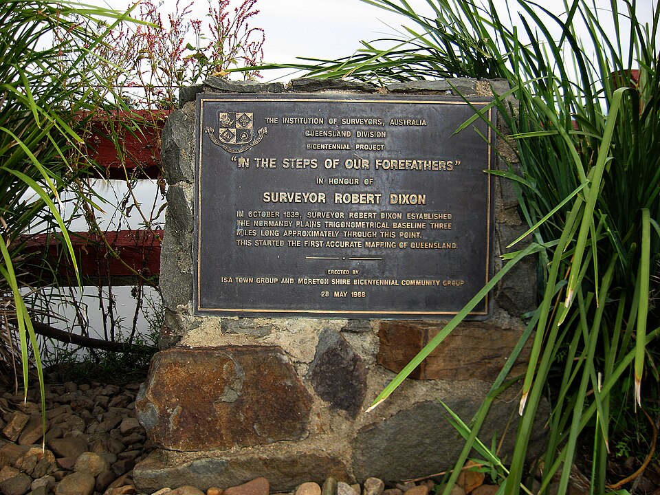
Robert Dixon memorial cairn
Harrisville railway station
The Fassifern railway line (Queensland's first branch railway line) opened from Ipswich to Harrisville on 10 July 1882 with the town being served by Harrisville railway station in Queen Street. It was 18 miles 50 chains (30.0 km) from Ipswich at an elevation of 179 feet (55 m) [27.8110°S 152.6666°E].
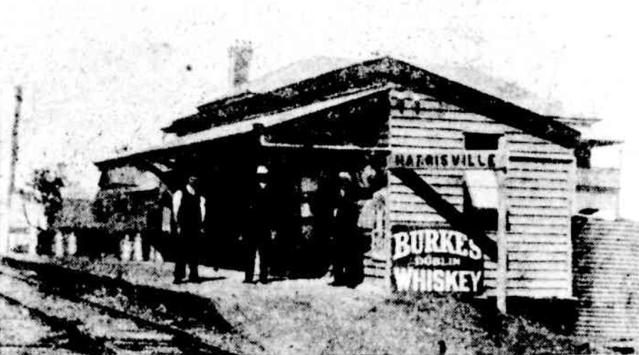
Harrisville railway station - 1909
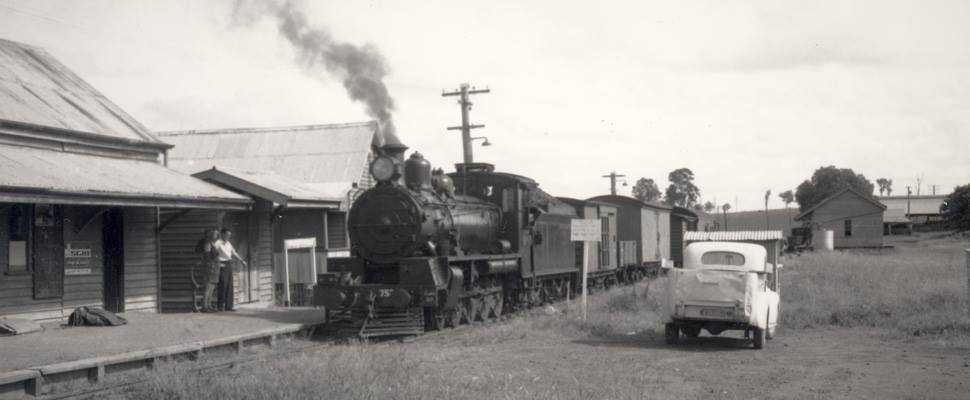
Harrisville railway station - 1962
Steam locomotive C17 No.752 arrives at Harrisville railway station, in 1962, with a short goods train. An interesting feature of the Harrisville station was that an ambulance stretcher was kept in a shed on the platform. When some one was in need of hospital care they would be wheeled on the stretcher onto the first available train to Ipswich. The rail section to Harrisville was closed in July 1964. The Goods shed in the above picture is still in existence at Harrisville and can be seen from Eagle Street.
Utilising Google Maps Lat/Long coordinate search, it places the Harrisville railway station just prior to the Eagle Street, along Queens Street.
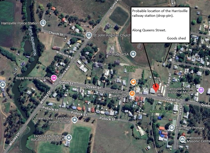
Probable Harrisville railway station location
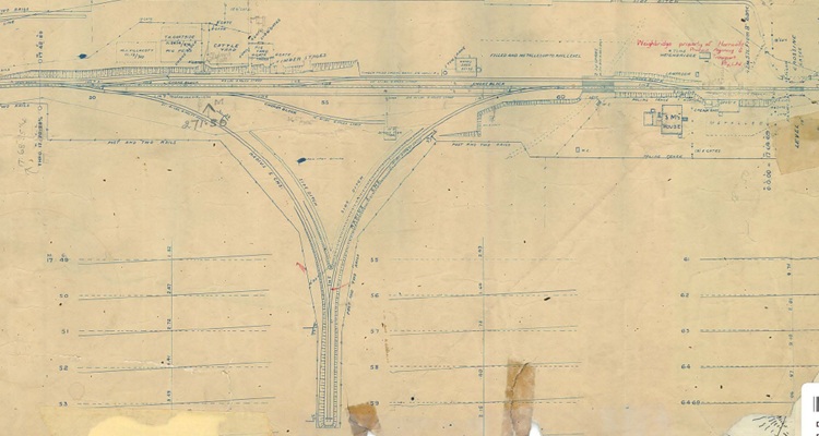
Harrisville railway station layout 1919 (QR drawing) [1]
Queensland Railways - Fassifern Branch - Harrisville Station (revised to May 1919)
Revision details from the Queensland Railways drawing as follows:
- 13-09-1928 - (27.4772) Cream Shed to be converted into Goods Shed
- 15-04-1929 - (29.1498) Produce shed for Mr. Hutchinson (19-04-1929
- 15-03-1934 - (32.2977) Approved improvements Trucking Yards (26-06-1934)
- 23-07-1937 - (37.1861) Truncating corner of yard
- 09-12-1937 - (37.1551) Extra accommodation at Trucking Yards
- 09-12-1937 - (37.2478) Approved to provide metal roadway, divert drain and construct con. Invert 36' x 18' (24-12-1937)
- 01-11-1939 - (39.2495) Approved to provide additional yard at trucking yards (09-11-1939)
- 01-02-1944 - (42-4063) (W.N. 6/44 07-02-1944) Foot crossing inserted at Station
- 09-01-1961 - (W.N. 2/61) Gates on Level Crossing removed
- 02-03-1964 - (W.N. 10/64) Closed to Public Traffic from 01-07-1964
- 10-01-1966 - (60.4454) Negotiations for change of Real property are being held
- 14-03-1967 - (66.7984) 6 ton Weighbridgesold to Harrisville Produce Agency and Transport Pty. Ltd.
Wilsons Plains railway station
On 12 September 1887 the Fassifern railway line was extended to Dugundan with Wilsons Plains being served by Wilsons Plains railway station on the corner of Wilsons Plains Road and Redhill Road. It was 20 miles 54 chains (33.3 km) from Ipswich at an elevation of 188 feet (57 m) [27.8362°S 152.6556°E].
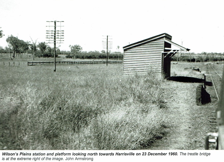
Wilsons Plains railway station - 1960 [2]
The old Wilsons Plains Station Mistress house still exists on the property, corner of Ellis and Jackson and Redhill roads.
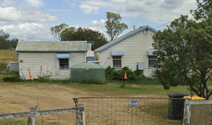
Wilsons Plains railway station - 1960 [3]
Utilising Google Maps Lat/Long coordinate search, it places the Wilsons Plains railway station just prior to the Ellis and Jackson Street, along Wilsons Plains Road.
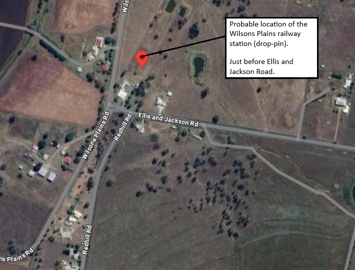
Probable Wilsons Plains railway station location
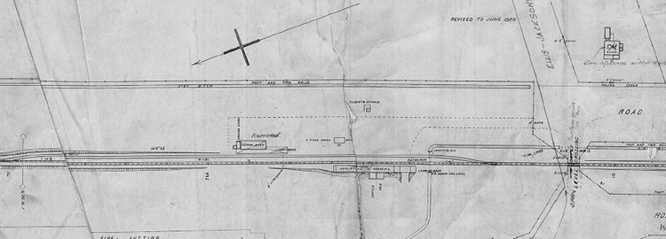
Wilsons Plains railway station layout 1927 (QR drawing) [4]
Queensland Railways - Fassifern Branch - Wilson's Plains Station (revised to June 1922)
Revision details from the Queensland Railways drawing as follows:
- 09-08-1956 - (55.7697) M2898 Station Mistress has been withdrawn. Approved to provide surface grids
- 01-05-1957 - (Cir. Memo 18/57 - W.N. 20/57) Level Crossing has now been converted into an open level crossing with surface type grids
- 07-12-1960 - (CO/4479 Cir. Memo 50/60 v W.N. 51/60) Goods Shed has been removed
- 02-03-1964 - (W.N. 10/64) Closed to Public Traffic from 01-07-1964
- 17-01-1985 - (CE's file 2160-94A) Proposed Telecom cable conduit crossing under closed section Railway OLC
Radford railway station
Radford takes its name from the railway station, which was named after the town of Radford in Nottinghamshire, England. The Radford railway station is located on Radford Road, 22 miles 09 chains (35.6 km) from Ipswich at an elevation of 194 feet (59 m) [27.8541°S 152.6437°E].
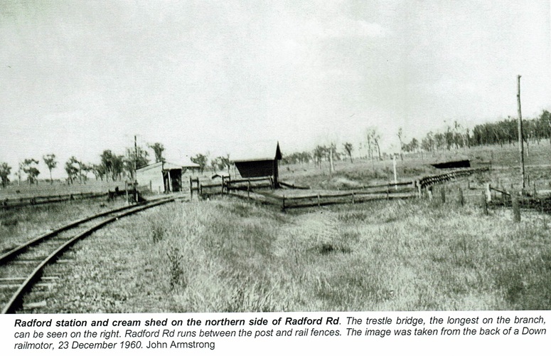
Radford railway station - 1960 [5]
Utilising Google Maps Lat/Long coordinate search, it places the Radford railway station along Radford Road (near the Redhill Road end).
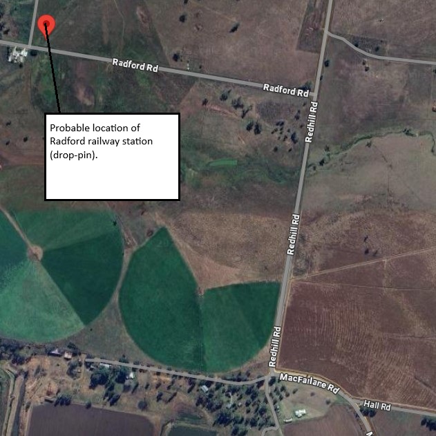
Probable Radford railway station location
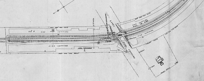
Radford railway station layout 1927 (QR drawing) [6]
Queensland Railways - Fassifern Branch - Radford Station (revised to June 1927)
Revision details from the Queensland Railways drawing as follows:
- 07-07-1949 - (49.2660) Cattle grids to be substituted for Level Crossing Gates and place worked as "D" stop
- 28-11-1949 - (W.N. 48/49) Closed shortly W.N.49, Cattle grids provided
- 02-03-1964 - (W.N. 10/64) Closed to Public Traffic from 01-07-1964
- [1] S00982-0001 Harrisville Station (May 1919) - (view the full version)
- [2] Look Out for Train: 7 - To The Scenic Rim 1 (page 42)
- [3] Google Street view (March 2024)
- [4] S00983-0001 Wilsons Plains Station (June 1922) - (view the full version)
- [5] Look Out for Train: 7 - To The Scenic Rim 1 (page 43)
- [6] S00984-0001 Radford Station (June 1927) - (view the full version)