
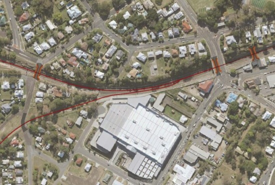
In the late 1870's agitation for a railway to serve the Boonah district received some recognition by the Government and several routes were surveyed. In 1880 they adapted one which followed the road to Harrisville. This was the first branch line approved in Queensland and as it required roadside construction it was necessary for legislation to be passed. The Railways and Tramways Extension Act of 1880 was passed.
The plan of the first section of the line from Ipswich to Dugandan was approved by Parliament on November 2, 1880. The Fassifern railway line became later known as "The Boonah Line". The section from Ipswich to Harrisville was opened on 10 July 1882 with the Fassifern Junction where it began its journey near the northwest corner of present day Bunnings - West Ipswich. Stops along the route were, Little Ipswich, Churchill, Loamside, Hampstead, Purga, Goolman, Hill side, Rockton, Peak Crossing, Flinders, Churchbank and the destination Harrisville was opened September 1882. The journey took one and a half hours.
The Harrisville Boonah contract was let in 1885 and completed in 12 September 1887. The route was from Harrisville, across Black Soil Plains, near Wilson's Plains and up over the Teviot Range and down to Dugandan after following the ridge for some miles. Stops were provided at Wilson's Plains, Radford, Munbilla, Anthony, Blantyre, Roadvale, Kalgun, Teviotville, Hoya, Boonah and the destination Dugandan. The line closed in June 1964.
Munbilla, being served by the Munbilla railway station on Macfarlane Road, had the Mount Edwards branch line branching off from the Fassifern line immediately south of the Munbilla railway station. The Mount Edwards line opened to Kalbar on 17 April 1916 and to Mount Edwards on 7 October 1922. The Mount Edwards line closed in 1960.
Today there is very little evidence of the railway lines, however you can still see remnants of the railway path using google maps.
Ipswich to Dugandan
The following text has been extracted from the 'Queensland Railway Tourist Guide' [1] and provides a quaint description of the countryside and journey along the branch line.
This is a short line of 36 miles, extending from Ipswich away south towards the McPherson Range. It leaves the main line in Little Ipswich and passes away across undulating forest ridges, covered by eucalyptus for the first mile or two, when it enters an agricultural country with farms here and there on both sides, and this continues to Harrisville, at 18 miles, a small township on flat country in the midst of a rich agricultural district.
On the way to Harrisville you pass several small stations, among them the Peak Crossing, on a beautiful apple-tree flat, like an extensive park. Here is a large saw-mill and also several private residences. Mount Flinders and his three attendant peaks tower aloft on the left. Beyond Harrisville a couple of miles you cross Wilson's Plains, named after the first owners of Mount Flinders station. This is a fine rural scene, farms and green fields frescoing the plain far away to the foot of the main range beyond, and cosy farm houses enbosomed in gardens and haystacks, a pleasing picture of a peaceful and prosperous industry. Here and there are small herds of cattle, horses, and sheep grazing on the open fields. Next to Wilson's Plains is Radford, a station standing near the head of a long pyramid-shaped plain, which runs away up into a point terminating on gum and ironbark ridges.
Next station is "Munbilla" situated in open forest of ironbark and Moreton Bay ash, a green swamp down on the flat to the right. This is the site of the proposed deviation of the via recta line from Brisbane to Warwick. Next station is called "Anthony," after a local resident, and after passing beyond this a mile across gum and ironbark ridges, the train enters the Dugandan Scrub, a vast expanse of dense brigalow brush covering low hills and valleys for miles in all directions, a splendid tract of rich agricultural land, every foot of which is selected and much of it cleared and cultivated. This line of railway really runs through and into one of the finest tracts of farming country in Southern Queensland, combining the glorious advantages of prolific soil and remarkably healthy climate. The elevation also secures it absolutely against even the possibility of floods. The principal timber in this scrub is brigalow, called "Cowpanby" and "Bonooro" by the natives. Here too are many bottle-trees (Sterculia rupestris), the "Jinbiggaree" of the natives, some of them of gigantic size. In appearance the scrub resembles that which covers the hills of Rosewood from between Walloon and, Grandchester right away across to the Brisbane River.
The journey through this district has a special charm of its own. The scenery is peculiar to itself. Magnificent pictures reveal themselves at intervals where the farmers' clearing enables you to look far out into the scene beyond. It is an ever-changing panorama, sudden in the transformations, beautiful in the diversity. At one moment surrounded by fields, cottages, and gardens, looking down on you from the crest of the green slopes, the whole forming a neat square cut out of the solid scrub, then you come unexpectedly on the summit of a ridge, cleared on both sides, and gaze down in rapt admiration on far-off valleys, where the farms and houses look like green islands and white rocks in that sombre sea of dark-grey scrub, and beyond are low hills, rising ever higher, hills beyond hills, until they terminate in the towering mountains of the Main Range, sweeping round from right to left in all fantastic shapes; towers, peaks, table-tops, rock turrets, and superb cloud-capped palaces of nature, standing in serene immobility against the clear blue sky, a wild, storm-tossed ocean of mountains piled in earthquake confusion, as if some Otus and Ephialtes had attempted there to scale the temple of the gods, as in the days when:
"Heaved on Olympus tottering Ossa stood;
On Ossa Pelion nods with all his wood."
Then the magician waves his wand, and shutting out that splendid scene, ushers you into little valleys, where you pass through fields of maize, cottages on both sides, fields sloping to the railway line, gardens on the hills between you in the sky line, and surrounding all the grey brigalow scrub stretching away right and left to the ranges. Far away on the hill-tops and hill-sides you behold the houses and clearings of the enterprising settlers, the hardy pioneers, of the second stage of civilization.
Pass Blantyre, with its adjoining valley and surrounding home-steads, past Teviotville and Hoya, and you arrive at the little neat progressive township of Boonah, embosomed so far in surrounding scrub, which is being rapidly cleared away. Boonah is the native name of the bloodwood (E. Corymbosa). Here the visitor will be surprised to find one of the most commodious and comfortable, country hotels in the colony. A mile beyond Boonah is Dugandan, the present terminus of the line.
- [1] Queensland Railway Tourist Guide (Publication year 1891) - pages 71-72 (download the full version)